French Prairie Bridge Project Status & Milestones
Project Status
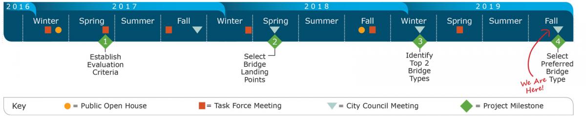
The currently funded French Prairie Bridge Project led by the City of Wilsonville in partnership with Clackamas County, Metro, and the Oregon Department of Transportation is scheduled to take place between fall 2016 and early 2020.
At the completion of this preliminary design project, the City of Wilsonville and regional partners will have the information needed to determine whether to pursue final design and construction of the French Prairie Bridge. This includes identifying the preferred bridge design, potential environmental and community impacts, and cost estimates for completing project design and construction.
Building on the work of a technical team and task force and public input, the Wilsonville City Council and Clackamas Board of County Commissioners selected a preferred alignment in May 2018. In spring 2019, the French Prairie Bridge Task Force recommended that the Wilsonville City Council and Clackamas Board of County Commissioners select the suspension bridge type as the preferred bridge type for the project. Five bridge types were considered through 2018 and early 2019, and the Task Force made this recommendation based on public input and considerations of cost, seismic resiliency, aesthetics, and impacts to the natural environment.
Project Milestones
The process of planning and developing preliminary designs for the bridge will be organized around five milestones:
Establish Evaluation Criteria (complete)
Evaluation criteria serves as a tool for comparing alternatives and making decisions about the bridge. The criteria were finalized after obtaining public input on the goals and objectives for the project.
Select Bridge Landing Points (complete)
Three potential bridge alignments located between the I-5 Boone Bridge and the Portland and Western Railroad Bridge were assessed based on the evaluation criteria. The Wilsonville City Council and Clackamas Board of County Commissioners (selected) the preferred alignment (known as W1) after considering public feedback and the recommendation of the project Technical Advisory Committee and Task Force.
Identify Top Two Preferred Bridge Types
Bridge types representing a range of styles and costs will be considered based on the selected bridge location. The Clackamas Board of County Commissioners and Wilsonville City Council will select two of the alternatives for further study after listening to public feedback and the recommendation of the project Task Force.
Select Preferred Bridge Type
Photo realistic renderings and additional analysis of the top two bridge type alternatives will be prepared. The Clackamas Board of County Commissioners and Wilsonville City Council will select the preferred bridge type after reviewing public comments.
Complete Conceptual Design Plans
Once a preferred bridge type is selected, the engineering team will develop the conceptual design and cost estimate for the bridge structure and its connection points on each side of the river.
Bridge Alignments Considered
")
Alignment W1 - (selected)
Alignment W1 is located at the far west edge of the project area, adjacent to the Portland and Western Railroad facility. The north end of the path connects to the west shoulder of SW Boones Ferry Road in Boones Ferry Park. The south end of the path connects to NE Butteville Road opposite the Boones Ferry Boat Launch parking lot.
The path through the W1 alignment corridor is approximately 2,000 feet long. The main span crossing of the Willamette River is approximately 750 feet in length. The total bridge length, including approach spans, is anticipated to be approximately 1,200 feet long. Retaining walls are anticipated to minimize property impacts at both ends of the alignment.

Alignment W2
Alignment W2 is located roughly in the middle of the project area. The north end of the path connects to the south shoulder of SW Tauchman Street east of SW Magnolia Avenue. The south end of the path connects to NE Butteville Road south of NE River Vista Lane.
The path through the W2 alignment corridor is approximately 1,900 feet long. The main span crossing of the Willamette River is approximately 700 feet in length. The total bridge length, including approach spans, is anticipated to be approximately 1,200 feet long. Retaining walls are anticipated to minimize property impacts at both ends of the alignment.

Alignment W3
Alignment W3 is located at the far east edge of the project area. The north end of the path connects to the south shoulder of SW Tauchman Street at the entrance to the waste water treatment plant. The south end of the path connects NE Butteville Road, well south of NE River Vista Lane.
The path through the W3 alignment corridor is approximately 2,550 feet long. The main span crossing of the Willamette River is approximately 800 feet in length. The total bridge length, including approach spans, is anticipated to be approximately 1,000 feet long. The second bridge is approximately 140 feet long. Retaining walls are anticipated to minimize property impacts at the north end of the alignment.